Validate Topology

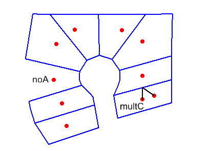
The Validate Topology tool is used to test the assumption that topology is represented by boundaries which surround centroids, with one centroid for every area. If a failure is found, text elements are placed that describe the nature of the problem. For each error, a line is drawn from the origin of the text message to one of the failed elements. The text is placed using the active text settings and level.
To validate topology:
- Place a fence around the target linework.
- Select the Validate Topology tool.
- Initiate the processing with a data point.
- Review the content of the Results dialog.
- The results can be saved or appended to a text file by selecting the appropriate option from the Results dialog File menu.
Key-in: FENCE VALIDATE TOPOLOGY